- גרסה: V6.3
- גודל הורדה: 20.43 MB
- שוחרר בתאריך: 14-08-2009
- מערכת הפעלה: iOS 8.0 ומעלה
- תאימות:
- מתאים עבור: גילאי 4 ומעלה
- מחיר בחנות: ₪ 13.90 (במקום 15.90 ש"ח, ירידת מחיר לזמן מוגבל) עודכן ב28 באוקטובר 2017.
שתפו אפליקציה זו עם החברים
EasyTrails GPS is the GPS tracker application for your iPhone.
The perfect application for those who are passionate about OUTDOOR ACTIVITIES and TRAVELING, everybody who likes outdoor sports, and not only.
- Featured by Apple in November 2014
- BEST OUTDOOR APP 2009 by 148apps.com
- BEST Italian APP 2011, 2013 Sport by macitynet.it
- More than 100 weeks at top 10 Sport IT
- More than 14 weeks at overall top 10 IT
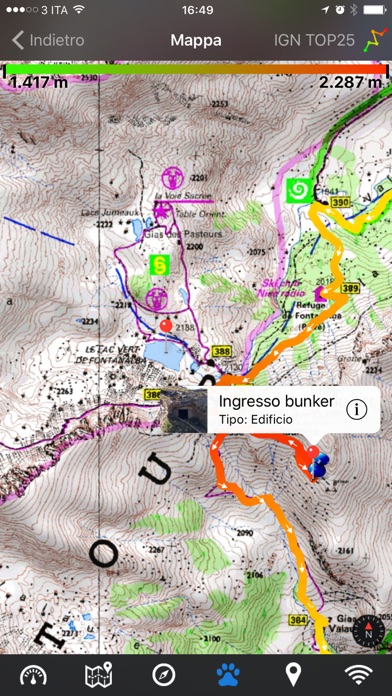
Are you going for a bike or motorcycle ride? Well, EasyTrails GPS will tell you how many miles you traveled, how much time you spent, how high you climbed and many other details. In real-time it will show you the course on a map, comparing it with downloaded tracks and points of interest.
You can import or share all tracks and waypoints, photos and ideas for new journeys with your friends.
Share where you are on Facebook and Twitter through your GPS position, and export your tracks in standard formats, so you can review them on Google Earth, SportTracks and TrailsRunner. Or simply upload them to online services like Garmin Connect, or many others.
It's possible to import tracks by e-mail or Safari (EasyTrails can handle GPX, KML/KMZ and ZIP file formats), or by wi-fi networks, using an improved and easy to use web-based sharing feature.
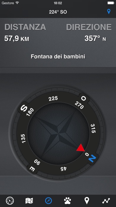
Calculate routes and let EasyTrails guide you using the new navigation capabilities. You can also let it guide you through previously recorded tracks.
Additionally, EasyTrails GPS can communicate with navigators like Maps, Google Maps, TomTom or Waze (if installed) for more advanced guidance needs.
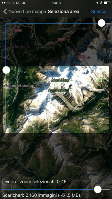
Load custom cartography, EasyTrails supports KMZ and MBTILES formats.
EasyTrails GPS is easy to use and extremaly accurate. It ensures the maximum duration of battery thanks to the possibility of recording in "StandBy" mode. However, be aware that use of GPS, even in background, will have a significant impact on battery duration.
► For more info, visit our website: www.easytrailsgps.com
NEW FEATURES:
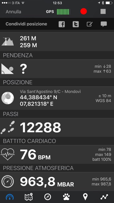
► Heart rate monitoring (paid)
We added the ability to connect to compatible Bluetooth heart rate monitors (such as Polar H6 and H7 devices). Heart rate can be seen in real time from the dashboard.
With the 'Heart rate monitoring' in-app purchase:
- heart rate data will be associated to GPS tracks
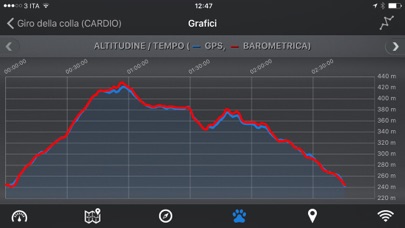
- saved tracks will have an extra heart rate chart
- heart rate data will be saved to HealthKit
Additionally, with the 'Colored tracks' in-app purchase, it will be possible to highlight heart rate data directly on the map screen of a recorded track.
OTHER FEATURES:
- Support for many different map types
- Support for different coordinate systems
- Support for user-loaded offline cartography (KMZ and MBTILES)
- Export tracks (single or multiple) in standard formats (GPX, KML/KMZ and CSV), with their associated waypoints and pictures
- Import tracks (GPX and KML/KMZ)
- Import waypoints (GPX and KML/KMZ)
- Resume recording of tracks
- Save waypoints with photos and descriptions
- Navigate to a point of interest
- Sharing via Facebook and Twitter
- Follow a path/track
- Navigate (distance / direction) towards any waypoint
- Navigate (distance / direction) towards any track marker (start / pause / resume / end points)
- Advanced Navigation to a waypoint using any navigation app you may have installed
- Upload tracks to GPSies (http://www.gpsies.com)
- Upload tracks to SportTracks (http://sporttracks.mobi)
- Upload tracks to OpenTrail (http://www.opentrail.us)
- Upload tracks to OkMap (http://www.okmap.org)
- Real-time visualization of distance, speed, altitude bearing and other data
- Map Visualization in different modes: street map, satellite, hybrid, terrain
- Charts (elevation profiles, ...)
- Digital Compass
- Heart rate monitoring
- Turn by turn directions
- High battery duration (record in standby)
- Select between metric, imperial and nautical measuring systems
- Intuitive and User Friendly interface
- Lightweight, reliable and accurate
- Doesn't require internet connection
הורידו עכשיו את EasyTrails GPS 6, אפליקציה ספורט שפותחה במיוחד עבור אייפון ואייפד ע"י Zirak s.r.l.. נשמח לשמוע מכם תגובות, שתפו אותנו בחווית השימוש, שאלות או טיפים שימושיים על EasyTrails GPS 6.
צריכים עזרה? נשמח לעזור לכם להשתמש באפליקציית EasyTrails GPS 6 באמצעות מדריכי וידאו, עזרה, טריקים ועוד.