- גרסה: V7.1
- גודל הורדה: 10.4 MB
- שוחרר בתאריך: 12-02-2010
- מערכת הפעלה: iOS 9.3 ומעלה
- תאימות:
- מתאים עבור: גילאי 4 ומעלה
- מחיר בחנות: ₪ 35.90 (במקום 39.90 ש"ח, ירידת מחיר לזמן מוגבל) עודכן ב29 באוקטובר 2017.
שתפו אפליקציה זו עם החברים
Your iPhone or iPad becomes a high-performance GPS receiver with USGS, US Forest Service & Canadian topo maps, even where there is no cell signal!
Headed into the wilderness? Always know where you've been, where you are, and where you’re going. Highest quality track recording, best route navigation and most accurate Estimated Time of Arrival of any available hiking app. No sign-up, ads, subscription or in-app purchase required, making this less expensive & less hassle than the “free” or subscription apps.
Use for hiking, backpacking, biking, canoeing, kayaking, geocaching, camping, sightseeing, 4WD exploring & skiing. Recommended as the top choice in “Essential Gear for Safe Hiking”.
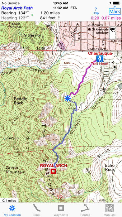
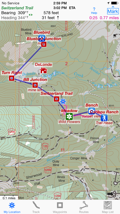
TRACKS, WAYPOINTS & ROUTES
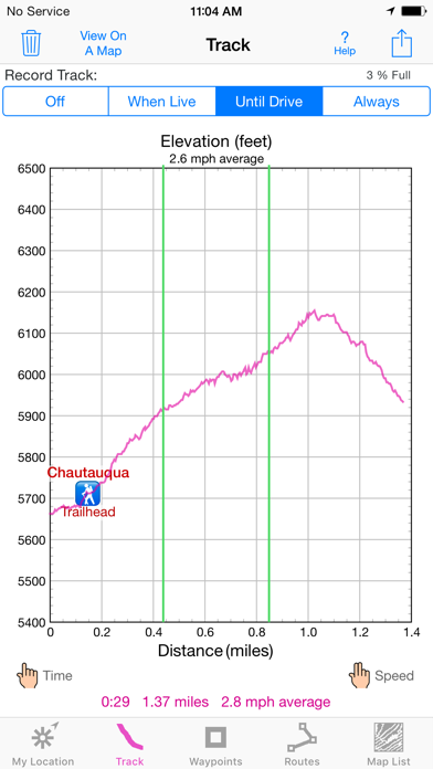
Record a track as you walk, even in the background. View it on the map. Trip Timer & Odometer.
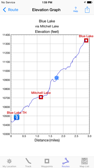
Show an elevation graph of your track or a route with altitude data. View date, time & average speed of track points. Measure the area inside a closed path.
Mark waypoints by their position on a topo map or a satellite map, by tapping a geotagged photo, by projecting from a known point or by searching place names. Refine a waypoint position when you arrive.
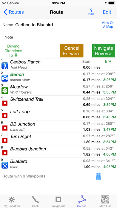
Set a quick GoTo waypoint or a full route & see the heading, direction, distance, elevation change & Estimated Time of Arrival at your destination & intermediate waypoints along the trail.
Create routes using waypoints, recorded tracks, or imported GPX or KML files. Advanced route editing.
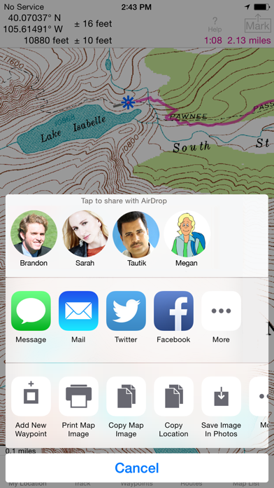
Export GPX & KML waypoint, route & track files via eMail, Messages, Copy To, AirDrop, iCloud Drive, Dropbox or iTunes.
Send KML files to display immediately in Google Earth. Receive KML files from Google Earth.
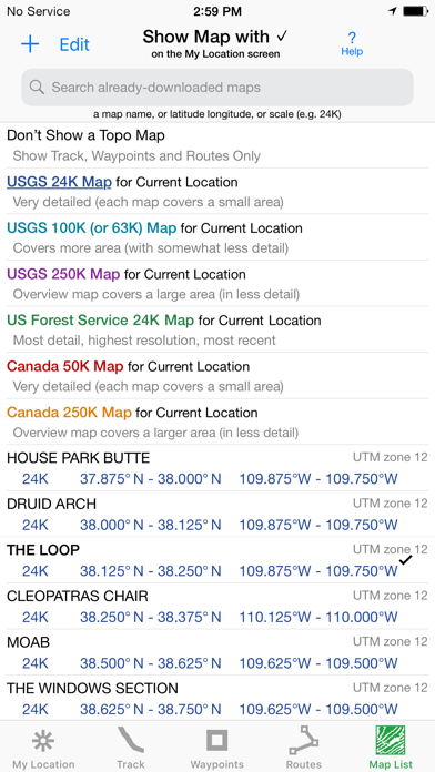
NO EXTRA CHARGE FOR TOPO MAPS
USA: Newest (2015 or later) US Forest Service 24K maps
USGS 24K maps for all 50 states, Guam, Puerto Rico & the US Virgin Islands
USGS 250K & 100K (63K for Alaska) maps for all states
Canada south of 54° latitude: National Resources Canada 50K maps for Alberta, British Columbia, New Brunswick, Nova Scotia & Prince Edward Island, and 18 Canadian National Parks
Download using WiFi or cell service.
Stitches beautiful richly detailed offline topographic map images for seamless coverage across map boundaries.
Store up to 1024 maps to use in the wilderness without cell service. Maps from our server download faster & use less of your monthly data allotment.
Includes map legends.
Print & Share map images overlaid with waypoints, routes & tracks.
Measure distance and direction between any 2 points.
USE THE UNITS YOU PREFER
miles, nautical miles or km. ft or meters
Degrees, Degrees/Minutes, Degrees/Minutes/Seconds or UTM
°True or °Magnetic
HOW TOS
Tap Help in the App
Online Manual on iHikeGPS.com
Twitter: @iHikeGPS
Email developer: [email protected]
WHAT OTHERS SAY
“I am VERY impressed!!!…It pretty much blows…, my previous fave GPS app, out of the water. Your track recording features, fast map downloads, and well thought out interface make it a real winner. It's very sophisticated software, and makes my iPhone just about as good as $600 Garmin… Actually better, in a lot of ways”-John in OR
“Perfect for anyone camping, fishing & hiking, it'll provide great detail when you need it the most…for anyone who takes the great outdoors seriously”-David on HandheldItems.com
“…thank you for developing IHIKE GPS…what a great product it is. I am impressed!…I use it hiking, biking, skiing & Jeeping”-Ammon in CO
DEVICE REQUIREMENTS
No device requires a cellular data plan to use iHikeGPS.
WiFi+cellular iPad 2 & later, and iPhone 4S & later support full navigation.
WiFi-only iPad 2 & later, and iPod touch (5th gen) & later require an iOS-compatible external GPS receiver to show your location in the wilderness & record tracks. View maps using the iOS device alone.
Continued use of GPS running in the background can dramatically decrease battery life.
Your dream of hiking adventures reaches new heights with iHikeGPS!
הורידו עכשיו את i Hike GPS : USA + SE & SW Canada Topo Maps, אפליקציה נסיעות שפותחה במיוחד עבור אייפון ואייפד ע"י James Associates Inc.. נשמח לשמוע מכם תגובות, שתפו אותנו בחווית השימוש, שאלות או טיפים שימושיים על i Hike GPS : USA + SE & SW Canada Topo Maps.
צריכים עזרה? נשמח לעזור לכם להשתמש באפליקציית i Hike GPS : USA + SE & SW Canada Topo Maps באמצעות מדריכי וידאו, עזרה, טריקים ועוד.