- גרסה: V2.5.8
- גודל הורדה: 45.13 MB
- שוחרר בתאריך: 08-07-2011
- מערכת הפעלה: iOS 9.3 ומעלה
- תאימות:
- מתאים עבור: גילאי 4 ומעלה
- מחיר בחנות: ₪ 55.90 (במקום 63.90 ש"ח, ירידת מחיר לזמן מוגבל) עודכן ב29 באוקטובר 2017.
שתפו אפליקציה זו עם החברים
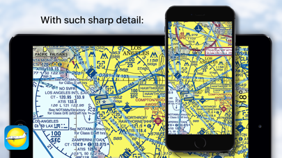
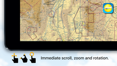
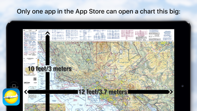
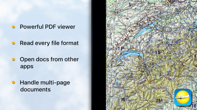
Got a PDF or a TIFF of an Aeronautical chart? Is that chart 31x24 inches with typography the size of a grain of rice? None of the document readers in the App store can view and scroll your chart with ease? We can, we are happy to work with files that need to become gigantic in size to read the fine print.
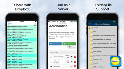
Note we don't supply the charts you must find those, in PDF, TIFF or JPEG/PNG formats, but once you have them, then you can view them with ease, either stored within the app via iTunes sharing, or passively cached from your Dropbox account.
Can act as a cloud server so you can upload/download/mange files and folders from your desktop browser.
We use our accelerated PDF viewing logic, and combined with our TIFF decoder we can deal most image formats. Expanding on our LargeViewer technology then means size is not a problem.
For charts under 36 megapixels effective resolution zoom and scroll time is ZERO! Above that we take an eye blink.
We can read almost every image file format: AVS, BMP, CUR, DIB, GIF, ICON, JNG, JP2, JPEC, JPEG, JPEG2000, JPG, MAT, MIFF, MTV, MVG, PBM, PCX, PGM, PICT, PIX, PNG, PNG8, PNG24, PNG32, PNM, PPM, RLE, SGI, TGA, TIFF, TIFF, TIM, VIFF, WBMP, WPG, SBM and XPM. Plus Apple quick look support for Office 97+, PAGES, RTF, iWorks, txt, and csv.
We support internal and external bookmarking, printing, TIFF to PDF conversion & free-form rotation, multi-page PDF books (any size, thousands of pages), and multi-page FAX/TIFF documents.
An aeronautical chart is a map designed to assist in navigation of aircraft, much as nautical charts do for watercraft, or a roadmap for drivers. Using these charts and other tools, pilots are able to determine their position, safe altitude, best route to a destination, navigation aids along the way, alternative landing areas in case of an in-flight emergency, and other useful information such as radio frequencies and airspace boundaries. There are charts for all land masses on Earth, and long-distance charts for trans-oceanic travel.
הורידו עכשיו את Aeronautical & Aviation Charts, אפליקציה שפותחה במיוחד עבור אייפון ואייפד ע"י Corporate Smalltalk Consulting Ltd. נשמח לשמוע מכם תגובות, שתפו אותנו בחווית השימוש, שאלות או טיפים שימושיים על Aeronautical & Aviation Charts.
צריכים עזרה? נשמח לעזור לכם להשתמש באפליקציית Aeronautical & Aviation Charts באמצעות מדריכי וידאו, עזרה, טריקים ועוד.